3 Things I Learned from Attending the 2020 BLOXHUB Summer School on Urban Resilience at the University of Southern Denmark

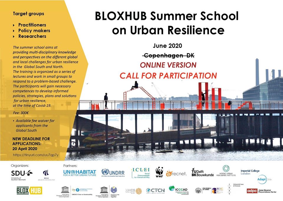
I am elated to be part of this year’s BLOXHUB Summer School on Urban Resilience 2020. The Summer School is under the International Urban Resilience Academy (IURA) program which serves as a platform for education, research, networking and capacity building activities on Urban Resilience hosted by the University of Southern Denmark. The BLOXHUB Summer School Urban Resilience brings together global practitioners, policy makers and researchers. This is the second the year that the University of Southern Denmark in Copenhagen hosted the summer school.

https://www.sdu.dk/en/forskning/sducivilengineering/iura/teaching+and+education+activities/bloxhub+summer+school+on+urban+resilience+2020

The summer school initial set-up was to invite participants to go to Copenhagen to attend the program. However, due the COVID 19 Pandemic, the plan changed and the organizers opted to conduct it on-line. The program itself was challenged by the Pandemic and proved its resiliency amidst the disaster. The conduct of the program served as a simple microcosm of what is happening globally. The program showed its resilience by understanding and analyzing the situation, being resourceful with the use of technology, and engaging the commitment of the participants and the organization as a whole.

But first, what is resiliency to you personally? When can you say that you are resilient? When can you say that your community or city is resilient? There are so many definitions of resilience – from being able to hang on through (survive) tough obstacles, being able to adapt to the current trials, up to being able to anticipate, plan, and not be significantly affected by the disaster when it arrives. My favorite is the UN Habitat definition of resilience which is “the ability of any urban system to maintain continuity through all shocks and stresses while positively adapting and transforming towards sustainability”. Wherever we are in the world, there will always be issues and problems that will come our way, how we deal with these challenges define our state of resiliency.

The lecture part of the program was organized in two ways. First is the General Webinar hosted by IURA wherein anybody can register and attend. The second lecture is the Community Sessions exclusive for participants. The General Webinar and the Community Sessions presents a combination of lectures, reports, tools and methods or presentation of best practices. The Community Sessions served as an in-depth discussion of the general webinar.

This year’s batch is very diverse both occupationally and geographically. Though diverse, it seems that issues in different parts of the world are similar specially in climate change and its effects, governance, and this current pandemic.

Bloxhub participants

We were assigned to different groups and were given tasks and weekly outputs / deliverables.

My 3 Major Takeaways from attending the 2020 BLOXHUB Summer School

1st Takeaway – Importance of Systems Thinking / Approach

A system for me is a group of interrelated parts wherein if something happens to one part it will affect directly or indirectly all the other parts. A system is a defined group of different parts or components. To appreciate a system, imagine an aching tooth, the aching tooth no matter how small will affect the function of your whole body or the performance of your daily activities. It is up to the researcher / student to provide the context or define the boundaries of your system. It may range from a simple to a complicated system. In my example, we can define the system as limited as the oral cavity or as extensive as its relationship to actual work performance or family relationships.

Our group looked at the Water, Sanitation, and Health (WASH) system in informal settlements in Asia during the Pandemic. We analyzed it geographically looking at different contexts, culture, and norms. We also looked at its temporal situation (before and during COVID 19 and what is ideal post-Covid 19). The problem of WASH is already significant in informal settlements before COVID 19. COVID 19 amplified the problem and further put families in greater danger. We also learned that problems go beyond the WASH system. This include poverty, livelihood and land ownership, among others. However, we defined our system boundary to only include access to WASH given the limited time in preparing our outputs.

Systems Thinking / Approach allows you to understand the problem deeper and better and gives you a comprehensive set of solutions. The Summer School advocated consistently the use of systems thinking.

2nd Takeaway – Use of Tools (Systems Approach and Collaborative Tools)

In the absence of face-to-face communication, the summer course used its resourcefulness and maximize the available internet tools that helped in delivering an effective program. All the tools or online applications presented in the course are all new to me. The three new online applications I learned are Slack, Miro Board, and Kumu.

Slack is very similar to Whatsapp, Viber, or Facebook. It is an online messaging application where team members communicate and work together. Similar to other applications, you can send different files through Slack. It is also nice that I can use different apps for different groups. I used Slack for the course while using other apps for personal mode of communication and expressions. https://slack.com/intl/en-ph/

One powerful tool for collaboration is the Miro Board. It helps group work together effectively. There is a common board where members can work simultaneously. It is the main collaborative tool used in the course. It is very effective in brainstorming wherein members may put digital sticky notes as inputs. https://miro.com/

I enjoyed making system maps in Kumu. It is a visualization platform used for mapping systems and better understanding relationships. The map can also be shared with group members and a good tool for collaboration. It provides great visual to the map of the system and the relationship of its elements. We also used Kumu in mapping our solutions / intervention using the Theory of Change. The map is also great as a communication tool to audience and stakeholders. https://kumu.io/

3rd Takeaway – Heart of Resiliency – Vulnerable Sectors

The first meeting of the group involved a workshop that requires group member to personally assess their knowledge (Head), skills (Hands), and advocacies (Heart). It is similar to stating your strengths and weaknesses, expertise and motivation. I was surprised that all of the groups chose to help or focus on the needs of vulnerable sectors.

Some of the participants are from international agencies but the focus of their advocacies are cities and communities and not at the country level. Some of the participants are also urban planners but instead of proposing “big plans” (like those of Daniel Burnham), they also focused on what the community really need and how to improve the daily lives of these communities. The advocacies are not that complicated but will create big impacts to the community.

As a City/Urban Planner, I advocate the localization of Sustainable Development Goals, Paris Agreement, Vision of the New Urban Agenda, etc. in our City. I realized that these big goals are just goals in paper agreed by higher level organization if not localized at the city or community level. These big goals will only serve as lip service if not alleviate the daily situation or struggles of the vulnerable sectors. All communities must be involved and committed to attain this global goal. Communities should be empowered to promote sustainability and resiliency. Probably, these are the reasons why most groups focused on local settings.

Attending the summer course is a great experience for me personally and professionally. Sometimes when you are at the local level, you may feel that what you are doing doesn’t contribute significantly to the betterment of the world. Now I believe that the fight to a sustainable and resilient world starts at the community / city level. I hope that more participants from Developing Countries will participate in the coming years. A very special thanks to the Organizer.

Is your City / Community Resilient?

107001989_330483181693679_593193230287442980_n

My Team – Javed Hussain (Pakistan), Shailendra K. Mandal (India), Ermin Lucino (Philippines) and Gusti Ayu Ketut Surtiari (Indonesia)


Local Citizens and Non-Citizens in the Middle of the COVID 19 Pandemic

Everything stood still during the Pandemic Lockdown. Schools, restaurants, businesses and public transportation, among others, stopped or operated in a limited capacity. Most of the people waited for the government to provide support in terms of financial assistance and food packages. The situation revealed two types of inhabitants (Beneficiaries) living in local governments (communities): the local non-citizens and the citizens.

First let us define what are citizens. Citizens are those who are living or resides in the community that are registered voters and/or included in the masterlist (whether as senior citizen, person with disability, solo parent, etc.) of the local government. Non-citizens are those living in the community who are not registered voters and does not directly deal with the local government. Usually these are the transient workers, company workers, stranded people, and those who by choice doesn’t want to engage or be part of the community.

During the pandemic (or any other disasters), the local government procures and prepares supplies for distribution and formulate programs to support its people. The local government uses the masterlist in identifying the number of food packages or the budget to prepare for the relief operation. However, during the pandemic, many inhabitants took to social media their cries of being excluded from the support. Sometimes, they air their complaints even before the actual distribution of support to the point of accusing local leaders of politicking, corruption, and discrimination.

On the government side, they cannot just allocate resources not based on actual data while on the side of the non-citizens, they are also part of the community contributing to its economy and development. Both sides have strong points. I do not want to decide which is the right argument. I only hope that this incident brought learnings on both sides. This way we can prevent this from happening again when disasters occur (and disasters will definitely occur whether we like or not).

If a person is a non-citizen by choice, he/she should be ready if he/she is not included in the masterlist of beneficiaries. However, being a non-citizen does not exempt him/her from government services such as peace and order, health, environmental programs, etc. Other non-citizens can easily be included in the local government masterlist if they just register in the local Commission on Election (COMELEC) Offices available in all local governments. This is a strong document that you are part of the community. However, take note that if a person fails to vote two consecutive times, he/she will be written off from the COMELEC masterlist. Another way is to get identification card from the local government Social Welfare and Development Office if you are a senior citizen, person with disability, solo parent, etc. There are many ways to become a citizen of the community which requires very minimal effort.

Local Government is tasked to promote the general welfare of its inhabitants (whether citizens or non-citizens). Thus, local governments formulate plans, programs, and activities in promoting what is best to the community. Masterlists are outdated the very time it is submitted and adopted. Everyday a person is being born (die) or transfer to and from the community which is not captured real-time in the masterlist. Local government should be adept in developing projections or actually capturing the number of its inhabitants on a regular basis. The Philippines has a lower level of local government below the city/municipal level. This is the Barangay (Village) local government unit. The duties of its barangay secretary are to keep an updated record of all inhabitants of the barangay containing the following items of information: name, address, place and date of birth, sex, civil status, citizenship, occupation, and such other items of information as may be prescribed by law or ordinance; and to submit a report on the actual number of barangay residents as often as may be required by the sangguniang barangay. Hence, it is the duty of the local government to have an updated record or masterlist. They should also promote the COMELEC registration of the inhabitants by making it accessible and convenient to the (qualified) people.

The Pandemic revealed this simple issue that created a big impact during the incident. I feel that it is both the duty of the inhabitants and the government to reach out to each other. The inhabitants to fulfill its moral duty of registering and voting and the local government to carry out its mandate, improve planning tools, and reach out/encourage its inhabitants to participate in local activities and governance.

I hope we learned from this experience and I hope that as a community, we are all prepared and focused on our next/future challenges.

Family Visit to one of the Global 7 Wonders of Nature – Puerto Princesa Underground River in Palawan, Philippines

It’s the nth time that I’ve visited the Underground River in Palawan but it seems this time it’s quite different. It might be because I am with my whole family or this is the first time for me as an urban planner to go back there. I may have a new set of lens when I look at things nowadays. Lets see.

For four years in 2000 – 2004 I regularly visit Puerto Princesa, Palawan twice a month to promote and sell pharmaceutical products. I worked as a medical representative back then in a multinational company. I like the presence of trees on both sides of the road, the tricycles as a major mode of transportation, the local restaurants, and the proud and hospitable (I’ll explain this later) people of the city, among others.

I was surprised when I went down the plane. The airport now is different. It was a simple building with modest facility back then but now the design is modern. The driver of the van that fetched us told me that it is already an international airport and that it is a new building. The old airport building is now an airforce facility. There are also international direct flights available in the airport. Puerto Princesa is now readily accessible to other countries.

We only had four days for this vacation. We alloted the first day to the City Tour, the second day to visit the Underground River, and the third day to just relax and enjoy the hotel facility (pool). We went back to Manila in the morning of the 4th day.

The kids enjoyed the City Tour (1st day). The highlight was the visit to the Palawan Wildlife Rescue and Conservation Center locally known as Crocodile Farm. They get to learn more about crocodiles and had the chance to have a family picture with a baby croc (the kids were really scared when their picture was taken).

I would not discuss in detail our visit to the Puerto Princesa Subterranean River National Park (Underground River). There are many blogs and stories about the place that you can easily check. In 1999, the Underground River was declared by UNESCO as World Cultural and Natural Heritage. In 2011, (through global text voting) the site was declared as one of the New 7 Wonders of Nature in the world.

To get to the site, you need to hire a van to Sabang then ride a motorized boat at the shore near the mouth of the river. A paddled boat is used to explore the river under the mountain.

I remember the series of rough roads going to Sabang port (access point to the park) in the early 2000s. The road now is paved all the way from the City to Sabang. The travel time before was around 3-4 hours. It just took us 2 and a half hours to reach Sabang. However, we became religious during our journey because of how fast our driver was driving (haha). He is careful in driving. But he was driving really fast!

There is a good queing system in the port. Our travel agent asked for our IDs and bought the tickets. Each motorized boat can only accomodate 6 to 8 passengers. We are only 5 plus our guide so we fit in one boat. It took us around 25 minutes to reach the shore of the park. To cherish your trip don’t forget to take pictures inside the boat and the nice view in the shoreline.

The 6-8 passenger limit per boat ensures that the boatmen all have opportunities to earn from tourists/visitors. This system also ensures convenience and safety of tourists because they seem to have a quality standard for the boats.

Upon arrival at the park, we were given audio equipment that will guide us inside the river cruise. There was no audio equipment available for tourists in 2000. Our tourist guide told us that the reason for the audio is that there are tourists from other countries that do not speak English. The audio equipment is equipped with different languages for different nationalities.

Before riding the paddle boat (the paddle boat can accomodate 10 persons), we were given a hard hat and a short briefing. Even it is the nth time that I’ve been to the Underground River, I am still excited to see this natural wonder. You’ll be refreshed about Elementary Science specially on stalactites and stalagmites formation and amazed to see them in real life.

Now with regards to the audio guide equipment. I know that it helps other nationalities understand and learn more about the site (and promote international tourism). But I miss the conversation with the boatman while he paddled the boat. Mind you, they are trained to converse in English and they are really experts in the area. I deliberately did not use the audio guide. I casually talk to the boatman but the trip seems lull and eerie (really dark inside) without the conversation. It is probably my fault for not using the audio guide. I tend to enjoy conversation with spontaneous questions and answers (something you cannot do with an audio guide). I am suggesting that the Puerto Princesa City Government / Department of Tourism provide option for a tour without an audio guide like before.

The kids enjoyed the trip to the Underground River. I know they learned a lot from this experience. I am glad that the City of Puerto Princesa is helping preserve the area for the enjoyment of the future generations.

We are back to the city proper on the third day. We rode their tricycles to go around the city. I noticed that there are less trees in the city as compared before. We went to the local Pasalubong shop and bought cashew nuts and cashew-related products, abaca coin purses, fancy bracelets, dried fish, etc. You need to learn to ask for discounts when buying pasalubongs. Don’t forget to also try their chicken inato, crocodile sisig and tamilok (mollusk) local delicacies.

In early 2000s, local residents of Puerto Princesa City are proud of being local defenders of city cleanliness. The city is known as the cleanest city in the country. Upon disembarking the plane, the stewardess announce that littering is strictly prohibited in the city (they did not do that anymore). Tricycles have small garbage containers in their vehicles. Drivers proudly tell stories that cleanliness starts at the local schools (young students) and they have strict laws on littering. The city is still clean but the people doesn’t talk about their local advocacies anymore.

I am proud that the Philippines has an Underground River. I am happy that I got to spend quality time with my family visiting this UNESCO World Cultural and Natural Heritage and New 7 Wonders of Nature. Thank you Puerto Princesa City for preserving the site. This is a must-see place even if you are not from the Philippines and even more if you are a local of this very beautiful and blessed country.

To Learn more about the place click the link: http://puertoprincesa.ph/?q=about-our-city/city-tourism-office-puerto-princesa

Addressing Traffic Issues without Building New Roads (but through Urban Planning)

The knee-jerk reaction of most people when it comes to finding solutions in traffic congestion is to build new roads. It seems to make sense when you are stuck in heavy traffic and you’re thinking that what if there is an additional lane it will surely help make the travel faster. It means that big streets can accomodate more vehicles. But what if it is no longer feasible to expand a current street or construct a new one? What would be our recommendations/solutions to worsening traffic conditions?

If the street is congested, would it help a little if we take away one car/vehicle from that street? Probably not. What if we take away 100 cars from that street? Well, it may have an impact to the said street. What if take away 1,000 cars? Impossible? Preposterous? What if I ask you to contribute in lessening the traffic by taking away your car? Now, I crossed the line but just try to read on with an open mind and let’s argue later, okay?

If you take 100 cars away from the street specially those cars without passengers (driver only), there would be 100 people angry why they were not allowed to bring their car. But what if we put these 100 people in 2 buses or let us say 4 buses, that would mean that the spaces occupied by the 100 cars would be traded to the spaces that will be occupied by the 4 buses. That would free a lot of space in the street and loosen traffic flow. What if these 100 people have access and will ride a train, then the streets be relieved and will have more space for other vehicles. What if we take away 1,000 cars from the street? Well, it is the same logic.

We need to have a convenient, reliable, efficient and effective alternative way of travelling than using our own car. We need to have a compelling reason not to use our car. We need to have a good public transport system. These are public buses, trains, trams, and even ferry boats. Though buses occupy our streets, it carries more people and occupies less space than individual cars. Are you willing to commute than bring your car to help alleviate the traffic issue? This is with the assumption that there is a safe and reliable public transport system. But what if the transport system is not reliable? This is the best altenative so we really need to demand from our goverment better public transport system.

Last week I had an interesting discussion with a friend who is now working as a director in the Department of Education. One of our topics was the traffic congestion problem in our country. He told me that government leaders and planners should consider the education system strategy to address congestion. He told me about school districts and how this system discourage students in commuting far to schools. This help lessens road usage/volume and does not further add to existing congestion.

I remembered the neighborhood unit concept of Clarence A. Perry in 1926 wherein focal point of planning of a community is the elementary school. The school is centrally located in a way that students can walk when they go to school. This eliminates the need for students to ride the car everyday. If there are 500 students in a school and all of them have cars, it means that there will be 500 less cars using the street. Less cars means less traffic congestion.

This is with the assumption that there are ample and safe spaces along the road for the students to walk or use their bikes. Sidewalks and bikelanes are also part of a road. Pedestrian and bikers are also road users. If you are a parent and it is not safe for your kids to walk or bike, for sure, you will use your car to bring them to their schools. Roads should cater all road users and not only the motorists.

Click the link to learn more about the neighborhood unit: https://www.planning.org/pas/reports/report141.htm

What if expound on Perry’s neighborhood unit to include not only the elementary schools as focal point of planning but also universities, workplace, and commercial centers. This way, not only the students will be encouraged to walk/bike but also people going to work. Of course, the context will not be limited to a community setting but probably more of a city or town level.

I am fortunate to live in the fast-urbanizing City of Santa Rosa, Laguna in the Philippines. It is the Automotive Capital of the country where most automotive manufacturing companies are located. It is also home to multinational food and beverage companies. It is one of the leaders in the Information and Technology / Business Process Management in the Philippines. This means that people have the option to work within the city and to not add in the congestion of Metro Manila. Big universities are also starting to locate in the city.

Santa Rosa unknowingly follows some of the principles of New Urbanism. New urbanism (according to newurbanism.org) is the creation and restoration of integrated diverse, walkable, compact, vibrant, mixed-use communities. It includes housing, work places, shops, entertainment, schools, parks, and civic facilities essential to the daily lives of the residents, all within easy walking distance of each other. It promotes the increased use of trains and light rail, instead of more highways and roads. According to the website, at present there are over 4,000 New Urbanist projects planned or under construction in the United States alone half of which are in historic urban centers.

The general gist of New Urbanism is to promote access to facilities frequented by the people (schools, workplace, commercial areas, parks, etc.). The primary mode of transportation is by walking. This means there will be less car and traffic congestion in areas that follow the new urbanism principles. My city still needs to establish safe spaces for people to walk/bike. We just finished crafting the city pedestrian and bicycle lane conceptual plan. We need the people’s support to implement the said plan.

Click the link to learn more about new urbanism: http://www.newurbanism.org/

In 1955, Lewis Mumford said “Building more roads to prevent congestion is like a fat man loosening his belt to prevent obesity”. New roads induces more traffic congestion. But if we are going to make roads he stated that “Every urban transportation plan should, accordingly, put the pedestrian at the center of all its proposals, if only to facilitate wheeled traffic; But to bring the pedestrian back into the picture, one must treat him with the respect and honor we now accord only to the automobile: we should provide him with pleasant walks, insulated from traffic, to take him to his destination, once he enters a business precinct or residential quarter.” The roads we built should be complete with pedestrian and bike space facilities.

Search this site to learn more about Mumford’s thoughts on Transport Planning: sustainabletransportationsc.org › …PDF The Highway and the City – Campaign for Sustainable Transportation

Constrution of new roads is costly. The government will need to buy the Road Right of Way. What if the owner does not want to sell? Well the government can use its coercive power to oblige the owner to sell but this takes a lot of time. Constructing the road itself also takes time. By the time the road was constructed, the number of cars already exceeded the additional road space/volume.

In order to address traffic congestion, we talked about Perry’s planned neighborhood concept where a person’s daily activities/needs is available within his/her neighborhood. This was supported by the New Urbanism principles. Mumford directly said that new roads further induce congestion and that if we will build new roads we must include the needs/space for pedestrians on the new roads. We also need to demand for a good public transport service so that we have the power to decide whether we will bring our own car or use the public transport system – to be part of the problem or part of the solution.

Now, does it really makes sense to immediately construct additional lane or new roads to address traffic congestion?

Source of Image: https://www.researchgate.net/figure/The-Clarence-Perry-Neighborhood-Unit-diagram-of-1929-Note-the-size-roughly-1-2-mile_fig9_307746242

SMART City in the Philippines?

What is a SMART City? When can you say that your city or community is SMART? In most developed countries, the direction is towards the development of SMART Cities. How about in developing countries? Is there such a thing as a SMART City?

The City of Santa Rosa in the Philippines has been positioning itself as a SMART City as early as 2014 through the leadership of Mayor Arlene Arcillas. Why is it important to be branded as a Smart City? Does it really make a difference?

The City of Santa Rosa is one of the industrialized cities outside Metro Manila. It is known as the “Automotive Capital of the Philippines” since almost all multinational major car manufacturing companies decided to establish in the city. It is also known as the “Next Wave City in Information, Communication, and Technology” having identified as an IT-BPO hub in the region by the national government. The City is also a tourist destination, Enchanted Kingdom (it is like Disneyland of the Philippines) is also in Santa Rosa. Does having all of these features in a city makes it Smart? Or there is more?

I was very fortunate to represent our Mayor as one of the panelists in the 2019 Regional Science and Technology Week (RSTW) and Regional Invention Contest and Exhibits (RICE) on September 26, 2019. The theme of the activity was “Science for the People: Enabling Technologies for Sustainable Development”. The session was Technology Talks about SMART Governance in SMART Cities. Even though I was one of the panelists, I surely learned a lot about what a SMART city is which I will share below.

Click to know more about 2019 RSTW: http://region4a.dost.gov.ph/

The session was moderated by the CALABARZON Regional Director Dr. Alexander Madrigal. The first speaker was Pres. Colin Cristie. He is the President of the Analytics Association of the Philippines (APP). His topic is about Framework for SMART Cities. He discussed about multiplied innovation wherein one innovation leads to another, the importance of data and correctly using these data, and building an analytics ecosystem in the country.

Click to know more about Analytics Association of the Philippines: https://aap.ph/

I am not an Information and Technology (IT) person, but as a Planner, I also believe in the importance of data as inputs to planning and implementing programs and projects. I thought about a program wherein local government units (provinces, cities and municipalities) collect data from census/survey. This is the Community Based Management System (CBMS). CBMS is a household survey that identifies the following indicators: health, nutrition, housing, water sanitation and access to safe water supply, education, employment and peace and order.

Click to know more about CBMS: https://cbms.dilg.gov.ph/

The conduct of the CBMS is costly and tedious. However, the importance of having these data is significant that the national government even enacted Republic Act 11315 also known as the CBMS Act to institutionalize data gathering to all LGUs in the country. The CBMS Act was approved on February 2019.

Click to know more about RA 11315 / CBMS Act: https://www.officialgazette.gov.ph/2019/04/17/republic-act-no-11315/

This mean SMART Cities use data in their decision making.

The second speaker was Mr. Alejandro P. Melchor III. He is the Chair of Smart Cities Committee of APP. His topic is about the Challenges and Opportunities in Developing Smart Cities. He talked about the emerging potential of the Philippines as the best country in terms of putting investments. He discussed how developed countries centered its national programs in developing SMART cities. He highlighted that when a city brand itself as a SMART city, development follows such as inprovement in its real estate market. Global institutions also pour out its support and resource to SMART Cities. He also presented the ASEAN SMART Cities Network wherein many cities in other countries are included in the network and only 3 cities (Manila, Cebu, and Davao) in the Philippines are included.

Click to know more about ASEAN SMART Cities Network: https://asean.org/asean/asean-smart-cities-network/

My take on Mr. Melchor’s presentation is that pursuing to be called/recognized as SMART City is a sound strategy in developing an LGU. Opportunities follow a SMART City. People benefits in such a city. Our Mayor is right all along to pursue a SMART City strategy. The country should at least consider this strategy. It also makes sense to start with cities because it is projected that by 2050 most of the people (68%) will be living in cities/urban areas. Let’s start with cities but let us not forget the municipalities/towns and other LGUs.

Click to know more about global population projection: https://www.un.org/development/desa/en/news/population/2018-revision-of-world-urbanization-prospects.html

The third speaker was Dr. Antonio M. Del Carmen. He is a Board Member of the National ICT Confederation of the Philippines (NICP) and president of Laguna Industry Network for Knowledge, Innovation and Technology (LINK IT). His topic is NICP’s Role in Developing Smart Cities. Dr. Del Carmen talked about the importance of developing a strong talent pool that can match the needs of the IT industry, specifically the IT-BPO industry. He introduced the importance of collaboration among Academe, Government and Industry. He also emphasized the willingness of NICP to help other cities and municipalities transform into a SMART city/municipalities.

My take from Dr. Del Carmen’s presentation is that SMART Cities are composed of skilled workforce. Developing your people will make you a SMART City. I also learned that the local government should not take all the burden in its objective of becoming Smart. Local Government should partner with the academe and industry to achieve this objective.

Click to know more about NICP: https://www.nicp.org.ph/about-us

The fourth speaker was Mr. Tristan M. Ocampo. He is the Technical and Design Promotion Manager of ABB Inc. His topic is Intelligent Technologies for SMART Cities: Building Blocks for Sustainability. Mr Ocampo talked about Intelligent Technologies, self-sustaining/sustainable cities, general characteristics and components of a SMART City, among others. He introduced their product ABB Ability. It helps by supporting an entire project ecosystem. He concluded his presentation by citing examples of cities and projects wherein ABB services improved/made the project SMART.

What I like about Mr. Ocampo’s talk is that he emphasized that programs and projects of a SMART City is defined by the needs and expectation of its constituents. It means that becoming a SMART City is contextual. Any city/town can vie to become a SMART City/Town. He also talked about sustainable city. For me, a sustainable city is economic, social, and environmental development.

Click to know more about ABB Inc: https://new.abb.com/ph

The fifth speaker was Mr. Joona Selin. He is the Executive Director NordCham Philippines. Mr. Selin discussed the possible and important role of NordCham by providing support to LGUs in its journey to become a SMART City. Cities in the Philippines can learn from other cities in their member countries on their experience of becoming a SMART city.

Click to know more about NordCham Philippines: http://nordcham.com.ph/about-us/

SMART City is relatively new in the country. The City of Santa Rosa and other cities will benefit from the lessons and experiences of other cities. However, Philippine cities should only adopt / copy principles suited to its local situation/context.

I was the sixth speaker. I talked about the role of the city in improving the quality of life of its constituents by providing efficient and effective programs. I presented Santa Rosa as the number 1 in local revenue collection in CALABARZON and how these collections fund the delivery of services. I mentioned also the presence of a rich talent pool and big universities that started to locate in the city. I also discussed Santa Rosa as a one of the 100 Super Cities in the world as identified by Tholons International in terms of digital services and outsourcing.

The seventh and last speaker was EnP. Angelica Francisco of the Development Academy (DAP) of the Philippines. Enp. Francisco talked about ISO 37106:2018 which provides guidance on establishing SMART city operating models for sustainable communities. She also discussed how is studying a SMART city template applicable to Philippine context.

To know more about ISO 37106:2018: https://www.iso.org/standard/62065.html

To summarize the points I learned from all the speakers, I will try to define what is a SMART City and why is it important.

A SMART City is the use of data in understanding the needs and expectations of constituents and subsequently providing programs that will improve the their quality of life. A SMART city is self-sustaining and promotes sustainable development. It is the use of technology in providing effective and efficient services. It is people development. It varies based on local context. To become a SMART City, the City must be certified in ISO 37106:2018 or the country’s SMART City agency. The positive benefits of pursuing to be a SMART city outweighs the challenges/issues that it may incur.

Let us promote the Development of SMART Cities/Communities. Thank you Department of Science and Technology (DOST) for guiding LGUs in becoming SMART Cities/Communities.

#DOSTCALABARZON

#ScienceForThePeople
#WeInnovateWeMakeADifference
#RegionalScienceAndTechnologyWeek
#RegionalInventionContestandExhibits
#RSTW2019
#RICE2019
#SmartCity
#CityofSantaRosa

NYC and LA – A Tale of Two Cities – Le Corbusier and Frank Lloyd Wright

USA – East and West Coast. Is one better than the other? In the eyes of an urban planner from another country, the difference between New York City and Los Angeles City is probably one of the best examples of extreme principles in urban spatial planning.

My wife and I got the chance to visit both cities on December 2016 to February 2017. I took a long vacation from work to visit relatives in LA and NYC. It is both an enjoyable and informative trip. It is like studying two planning principles and actually living it in their model laboratories.

Broadacre City was an urban planning concept introduced by the famous American architect Frank Lloyd Wright which first appeared in his book “The Disappearing City” in 1932.

Broadacre City was designed to be a continuous urban area (horizontal development / not tall buildings) with a low population density. The city had a futuristic highway and airfields. There are living units (farm, factory, roadside markets, leisure areas, schools, and living spaces) assigned an acre (4,046.856 square meters) Living units were organized in a way that people can access any service or commodity within a radius of one hundred and fifty miles accessible by road or air. The design was motor vehicle-friendly.

My relatives in LA all have cars. Each person who knows how to drive owns a car. Personal cars are their primary mode of transportation such as when they go to supermarkets, malls, workplace, outlets, etc. They live in subdivisions in spacious two-storey houses with garages, backyards and laundry areas. I am not comfortable driving in a different country, fortunate for us, we now have Uber.

Charles-Edouard Jeanneret-Gris is known with his pseudonym Le Corbusier. In 1935 he introduced his theory on urbanism and published it in La Ville radieuse (The Radiant City) in 1935. He stated that housing should be assigned according to family size and not economic position. He envisioned building up (vertically/buildings) and not out (horizantal/spatial). His plan is also known as “Towers in the Park”, proposed numerous high-rise buildings each surrounded by green space.

I stayed with my sister in Jersey City for two weeks and was able to stay also in Upper East Manhattan NYC for another week (one of her friends went abroad and he let us stay in his apartment for one whole week). My sister that time doesn’t own a car. She doesn’t need one. We always use the subway and buses to go around and even tried the ferry when we went to Brooklyn. My sister rented a car when we travelled outside the city (Washington DC). Everywhere you can see people walking.

Most people in NYC lives in medium-rise apartments. Their living spaces are small. If the building does not have its own laundry area, you need to go out to a laundry shop to wash your clothes. Living spaces are small but the rent is expensive. This is because of the high housing demand in the city. The city is also famous for its Central Park. It is a public space where people can enjoy their day with different activities. It seems like the park is a communal backyard / relaxation area for the residents.

Which is better? It depends on your lifestyle and preferences. If you enjoy a fast-paced environment living with neighbors next door then NYC is better. If you enjoy the freedom of driving your own car and owning a bigger house then the City of Angels better suits you. I met people that lived in NYC during the peak of their productive careers and later chose to retire in the west coast. I also met young people dreaming to work and live in the Big Apple.

NYC / Le Corbusier or City of LA / Frank Lloyd Wright?

How about you, where do you prefer to work and live?

References / For Further Reading:

https://www.smithsonianmag.com/smart-news/how-controversial-european-architect-shaped-new-york-180965073/

https://www.biography.com/artist/le-corbusier

https://www.citylab.com/design/2012/11/evolution-urban-planning-10-diagrams/3851/

https://www.worldatlas.com/articles/what-is-a-broadacre-city.html

Image of Radiant City from https://www.archdaily.com/794582/the-stories-behind-17-skyscrapers-and-high-rise-buildings-that-changed-architecture/57cadef9e58ececab70000d5-the-stories-behind-17-skyscrapers-and-high-rise-buildings-that-changed-architecture-image?next_project=no

Image of Broadacre City from https://www.moma.org/explore/inside_out/2014/02/03/frank-lloyd-wrights-living-city-lives-on-conserving-the-broadacre-city-model/

What it meant to be a Local Government Planner

What it meant to be a Local Government Planner

Last week, the City Youth and Development Office assigned Youth Representatives to shadow and learn from city elected officials and city department heads for a whole week. Unfortunately, last week was a hectic week for me wherein more than the normal number of urgent projects are ongoing. I managed to orient the youth assigned to be the young City Planning Development Coordinator (CPDC) but failed to ask for his feedback on what he learned from our office. This specific blog is for the non-planners who want to know more about local planning in the Philippines.

A City Planning and Development Coordinator (CPDC) is the chief or head planner in a city in the Philippines. Its counterpart is the City Plannning Director in the United States and Town Planner in the European Union.

A city is part of a group called the Local Government Units (LGUs) which are government organizations below the national or central government. The LGUs govern and provide certain basic services to its territory. There are several levels of LGUs. From highest to lowest: autonomous administrative regions, provinces, cities, municipalities, and the village level (barangays). There are 3 basic level of LGU head planners: provincial planning and development coordinator, CPDC, and municipal planning and development coordinator. The appointment of a planning and development coordinator is mandatory for provincial, city and municipal governments.

The operational guidebook (law) for LGUs is the Local Goverment Code of 1991 or Republic Act 7160.

To learn about more about RA 7160 click https://www.lawphil.net/statutes/repacts/ra1991/ra_7160_1991.html

In 1991, RA 7160 defined the qualification of a local planning and development coordinator in Section 476a as follows:

• a citizen of the Philippines

• a resident of the local government unit concerned

• of good moral character

• a holder of a college degree preferably in urban planning, development studies, economics, public administration, or any related course from a recognized college or university

• first grade civil service eligible or its equivalent

• experience in development planning or in any related field for at least five (5) years in the case of the provincial or city planning and development coordinator, and three (3) years in the case of the municipal planning and development coordinator

In 2013, Republic Act 10587 or the Environmental Planning Act of 2013 was enacted. This changed (added) the existing qualifications of an LGU planner – specifically the need for an Environmental Planning Board Certificate.

To learn more about RA 10587 click https://lawphil.net/statutes/repacts/ra2013/ra_10587_2013.html

In 2017, the Civil Service Commission (CSC) through CSC Memorandum Circular No. 10 series of 2017 released an Amendment to the (Quality Standards) QS of the Head Local Planning and Development Coordinator Positions in the Local Government Units. In 2018, the Department of Interior and Local Government (DILG) released a memo on the Reiteration of Civil Service Commission Memorandum Circular No. 10 series of 2017 compliance with Republic Act No. 10587 (Environmental Planning Act of 2013). This means that starting 2017 all new appointed planning and development coordinators (aside from the RA 7160 requirements) should be a licensed environmental planner.

To learn more about CSC MC 10, s. 2017 click the link: http://www.csc.gov.ph › MC2017PDF

To learn more about the DILG memo click the link: https://dilg.gov.ph/issuances/mc/Reiteration-of-Civil-Service-Commission-Memorandum-Circular-No-2017-10-in-compliance-with-Republic-Act-No-10587-Environmental-Planning-Act-of-2013/2679

What is the job of a local planning amd development coordinator? RA 7160 Sec. 476 enumerate the duties of a local planner.

First is to formulate integrated economic, social, physical, and other development plans and policies for consideration of the local government development council.

Integration means unity and alignment of sectoral plans and policies. There are 5 sectors considered in the LGUs. These are the social, economic, enviroment, infrastructure, and institutional. There are also subsectors per sector. For example in the social sector the subsectors are education, health, social welfare, protective services, parks and recreation and disaster preparedness and reduction, among others.

The local government development council (LDC) is separate from the local elected council. Sectoral plans originate from and approved by local development council. The members of the LDC are the heads of the component LGUs (provinces – all mayors in the provinces; cities/municipalities – all barangay chairmen in its territory), representatives of the district (congressman), and civil society organizations (which comprise 25% of the membership). The LDC approved plans is presented to the local elected council for adoption and approval.

The role of the planner is more of a facilitator ensuring the planning process is observed and there is participation in the formuation of the plan.

Second is to conduct continuing studies, researches, and training programs necessary to evolve plans and programs for implementation.

At present our city is planning and studying the establishment of a City College and formulation of a Transport Plan and Traffic Code. The study of the city college will be conducted by the city while the formulation of a Transport Plan and Traffic Code will be outsourced to planners specializing in transport management.

Third is to integrate and coordinate all sectoral plans and studies undertaken by the different functional groups or agencies.

There are several plans and studies at different levels that need to be integrated at the local level. Examples are the Sustainable Development Goals at the global level, Philippine Development Plan and Ambisyon Natin 2040 at the national level, plans of national (sectoral) government agencies, local plans of the higher level LGU (Province) and local plans of component/lower level LGUs (Barangays). The role of the planner is to make sure that their plan is aligned to other major plans.

Fourth is to monitor and evaluate the implementation of the different development programs, projects, and activities in the local government unit concerned in accordance with the approved development plan.

The LGU allocates a certain percentage of its annual budget to its annual Development Fund. These are capital outlay projects (mostly infrastructure) that should be implemented in a given year. The role of the planner is to monitor and evaluate the implementation of these projects.

Fifth is to prepare comprehensive plans and other development planning documents for the consideration of the local development council.

There are two major plans in any LGU. These are the Comprehensive Development Plan (CDP) and the Comprehensive Land Use Plan (CLUP).

The CDP is an integrated sectoral plan with a planning period of 3 to 4 years. The CDP has a Local Development Investment Program/Plan where projects are sourced out amd budgeted. The CLUP is a long-term land use plan with a planning period of 9 years. The CLUP is implemented through a Zoning Ordinance. The Zoning Ordinance guides the development of different land areas in the LGU.

The role of the planner is to ensure that the LGU has these two plans. The planner should also make sure that the plans are aligned with other plans and that utmost stakeholder participation is observed in the formulation of the plans.

Sixth is to analyze the income and expenditure patterns, and formulate and recommend fiscal plans and policies for consideration of the finance committee of the local government unit.

The Local Finance Committee is composed of the local planning and development coordinator, local treasurer, and local budger officer. The local finance committee provides advice to elected officials on the financial status of the LGU.

The planner together with the local development council (LDC) formulates and approve the annual investment plan (AIP). The AIP is the basis of the Annual Budget. Only programs, projects and activities included in the AIP are allowed to have an allocated budget to be implemented.

Seventh is to promote people participation in development planning within the local government unit concerned.

The local development council has 25% membership from non-goverment / civil society organizations. This ensures that stakeholders other than government actors are included in the development of local plans.

The plans that our office facilitated recently are the eco-tourism people’s park conceptual plan and the bikelane and pedestrian conceptual plan. Both underwent a series of public consultations with stakeholders.

Eight is to exercise supervision and control over the secretariat of the local development council.

The Office of the local planner provides the administrative work of the council. Secretariat functions include coodination with all members, setting of agenda, formulation of minutes and resolutions, etc.

Last but not the least is to exercise such other powers and perform such other functions and duties as may be prescribed by law or ordinance.

An idea or a policy in its early stage is usually assigned to the planner for his/her study. The mode of assigning this task can be through verbal request, a memorandum from a national government agency, an executive order, or a council resolution.

The tasks can be so diverse such as preparing the city for an audit (seal of good local governance), ISO certification, nomination of a city (Phillipine Business-Friendliness entry), transfer of a public elementary school to a new site, survey of new right-of-way for new roads, site planning, local speeches, etc.

The local planner should always be ready. The Office of the local planning and develoment coordinator should be composed of teams that are fast learner, dedicated, resilient, and thrive on a fast paced environment.

Being a local planner is both daunting and rewarding. Daunting because of the diverse roles and responsibilities. Rewarding because the planner has the opportunity to personally see and feel the output and outcome of their local plans.

Are you ready to be a local planner?

How to Formulate an Executive Legislative Agenda (ELA)

Are you a new Provincial / City / Municipal Planning and Development Coordinator (Head Planner) or perhaps a seasoned planner who is tasked by your local executive (Governor or Mayor) to facilitate the formulation of your Local Government Unit’s (LGU) Executive Legislative Agenda (ELA)? Are you a department head or a non-government stakeholder involved in the formulation of this very important document? Let me try to explain what an ELA is and more importantly how we formulate the said document.

I was promoted to head city planner on 2014. A local election was held on May 2016. On July/August 2016, a DILG memo was released stating that I need to assist the Department of Interior and Local Government (DILG) in the formulation of our City ELA. It was my first time to facilitate the formulation of the ELA. There was no guide accompanying the memo. Unlike the Comprehensive Development Plan (CDP) which has a DILG Guidebook and the Comprehensive Land Use Plan which has the Housing and Land Use Regulatory Board (HLURB) guidebook to follow, the formulation of the ELA does not have a guidebook.

It is again an ELA formulation season. DILG again sent out a memo (DILG Memorandum Circular 2019-114) stating what to do, specific timeline, and responsible officer (https://dilg.gov.ph/issuances/mc/Clarificatory-Guidelines-on-the-Formulation-of-the-Executive-Legislative-Agenda-ELA-/3012). The Memo stated the use of the CDP guidelines, however, the how-to formulate the ELA exclusively was not included in the memo.

My immediate response is to look for a guidebook on ELA formulation. Fortunately I found the following guidebooks: ”A Manual – How to Formulate an Executive and Legislative Agenda for Local Governance and Development” and “A Facilitator’s Guide – How to Formulate an Executive and Legislative Agenda for Local Governance and Development” published by Local Government Academy (LGA) and Philippines-Canada Local Government Support Program (LGSP). A newer version is The “LGU Capacity Assessment and CapDev Agenda Formulation Toolkit – A Guide to the new SCALOG and CapDev Agenda Processes and Tools Second Edition” also by Local Government Academy. The guidebooks may be downloaded online.

An ELA is a term-based (3-year) plan or document derived from the Comprehensive Development Plan (CDP) which contains the major development thrusts and priorities of both the executive and the legislative branches for the three year term of office. The ELA is mutually developed and agreed upon by the executive and legislative departments of the LGU in consultation with the various stakeholders. This is the first proof that the executive and legislative agree on their programs, projects, and activities of the LGU. If things go awry between the two (politically or otherwise), the planner should remind both that in the start of their term they agreed (ELA!) on the things they wanted to do for the betterment of their LGU.

I would like to share what I did in my city. It was not perfect and actually it is still a work in progress. I just hope that other planners would not go through my experience in 2016 where I desperately looked for the actual steps in ELA formulation.

I started the ELA process early (mid-June) by distributing a form to all department and unit heads. The objective was to prepare/condition the departments/units in identifying issues, goals and objectives, programs and projects, year of implementation, source of funding, indicative cost, need for legislative support, need for human resource support, and need for infrastructure support.

ELA Form

There was a turnover or leadership on July 1, 2019. In mid-July, together with our DILG City Local Government Operation Officer, we conducted a general briefing/orientation to stakeholders specifically department heads, unit heads, and elected officials. Below are the slides (based on the stated references) I used in the orientation:

ELA Orientation

The departments/units were group into sectors and its corresponding subsectors. The said groups underwent detailed briefing on the ELA process, their outputs and deliverables, and the timeframe. Each group assigned a leader, presenter, secretariat and documenter among themselves. After the initial briefing, they were expected to conduct separate meetings to finish their required outputs. Below is the hand-out discussed during the sectoral briefing:

ELA Sectoral Briefing

The ELA process may be tedious and time consuming. However, giving our stakeholders the chance to make their plan, collaborate with each other and work as a team may prove to be beneficial in the long run. For one, ownership of the ELA does not only belong to the elected officials but also to the people delivering the actual projects. This makes the projects in the ELA easily implementable. Second, teamwork and camaraderie is developed during discussion. This will make coordination better during project implementation. Third, the monitoring of the projects will be easier given the involvement and clear expectations of the agencies. Lastly, all sectors were given due importance in the formulation of the ELA making it holistic and comprehensive. Involvement of stakeholders and public consultation also make the ELA participative and inclusive.

My intention in writing this essay is to help specifically my fellow local planners and the people involved in the ELA formulation in general.

– EnP. Ermin V. Lucino, MPM, AICP, PMP®


Philippine Institute of Environmental Planners (PIEP) Supports the Achievement of Sustainable Development Goals (SDGs) by Promoting Good Governance through Governance Hubs in Provincial Road Projects

Philippine Institute of Environmental Planners (PIEP) Supports the Achievement of Sustainable Development Goals (SDGs) by Promoting Good Governance through Governance Hubs in Provincial Road Projects

EnP. Ermin Lucino, MPM, AICP, PMP®

“ROADS” literally and figuratively pave the way for development. It both serves as a link of the people to basic services and foundation and catalyst for economic development. It means that inadequate and dilapidated roads hinders the people’s access to basic services and economic development and opportunities.

“Paving the Roads to Sustainable Development Goals through Good Governance (Roads2SDGs)” is a national governance reform program in local roads management (LRM) and public financial management (PFM) targeting different provinces in the country. Roads2SDGs is an initiative of the Department of Interior and Local Government (DILG). DILG together with the Department of Budget and Management oversee the Conditional Matching Grant to Provinces (CMGP) project. It aims to improve the quality of the provincial local road network across the country by matching the fund from the national government with good governance practices at the provincial level.

The construction and rehabilitation of roads is aligned with the SDGs. The Philippines is one of the signatories committed to the achievement of these goals.

The 17 Sustainable Development Goals (SDGs) are a universal call to action to end poverty, protect the planet and ensure that all people enjoy peace and prosperity. The goals are interconnected and interdependent. It promotes partnership and pragmatism in making the right choices now to improve life in a sustainable manner. The SDGs provide clear guidelines and targets. It is an inclusive agenda.

Improving access and socio-economic development through construction and rehabilitation of roads supports the following SDGs:

SDGs Contribution of Roads to SDG
SDG 1 No Poverty Connecting communities to basic services and economic opportunities
SDG 2 Zero Hunger Enhancing food security by improving business of markets and profit and productivity of farms
SDG 3 Good Health and Well Being Connecting communities to health services and in turn health services to medicinal warehouses / suppliers
SDG 4 Quality Education Increasing safe access to educational institutions and opportunity for the youth and adults to develop new skills
SDG Gender Equality Ensuring gender responsive roads such as safe lighted pedestrian walkways
SDG 8 Decent Work and Economic Growth Increasing employment and economic access for all including the youth and persons with disability
SDG 9 Industry Innovation and Infrastructure Ensuring that the people living in rural areas live within 2 km of an all-season road. Promoting innovative road design.
SDG 13 Climate Action Ensuring resilient designed roads that will better withstand the effects of climate change
SDG 16 Peace, Justice & Strong Institutions Mitigating corruption, increasing transparency and ensuring responsive institutions through citizen participation
SDG 17 Partnership for the Goals Building multi-stakeholder partnerships for effective implementation and maintenance of roads

Blog 1

To get funding from the Conditional Matching Grant to the Province (CMGP), provincial governments are required to formulate and submit a Provincial Governance Reform Roadmap (PGRR) covering the year 2017-2022. The PGRR illustrates the performance targets for each reform area and the strategies to achieve and sustain these agendas. There are seven (7) Reform Areas in the PGRR. Four (4) reform areas are under Local Road Management (Local Road Information Management, Local Road Network Development, Local Road Construction and Maintenance, and Local Road Asset Management) while three (3) reform areas are under Public Financial Management (Internal Audit; Budgeting, Revenue Generation and Expenditure Management; and Procurement).

The United Nations Development Programme (UNDP) is the United Nation’s global development network. It advocates for change and connects countries to knowledge, experience and resources to help people build a better life for themselves. UNDP help achieve the eradication of poverty, and the reduction of inequalities and exclusion. They help (developing) countries to develop policies, leadership skills, partnering abilities, institutional capabilities and build resilience in order to sustain development results. UNDP Philippines partnered with DILG in the implementation of the ROADS2SDG Program.

Blog 2

The ROADS2SDGs have four major target outputs. These are formulation of quality assurance manual for roads and technical audit tools, governance reforms deliverables by the formulation of guidelines for provincial assessment and PGRR formulation, mentoring/coaching (developing local capacities) in local road management and public financial management, and by promoting citizen participation in road governance.

The G-HUBS (Holistic Undertaking Bridging Solutions for Governance) also known as Governance Hub was initiated by DILG and UNDP to assist in the implementation of the ROADS2SDGs program. The G-HUB is a regional organization that stemmed from a Memorandum of Understanding among the different private and state universities and colleges, Philippine Institute of Environmental Planners (PIEP), non-government organizations (NGOs) and people’s organizations (POs).

The role of G-HUBS in the ROADS2SDG program includes provincial assessment (conduct of courtesy calls, co-facilitation of provincial assessment and promotion of citizen participation), PGRR formulation workshop (co-facilitation of the workshop and promotion of citizen participation), follow-up coaching and mentoring (weaving through the SDGs in the PGRR), finalization of the PGRR until SP adoption (coach CSO participants to lobby adoption of PGRR), PGRR Implementation (organize / mobilize citizens’ monitors and advocate for the institutionalization of citizen-led monitoring), and PGRR Monitoring (advocate for the institutionalization of citizen-led monitoring). The G-HUBs were allocated a modest amount from UNDP to be used in their operation and delivery of outputs.

I belong to the Cavite-Laguna-Batangas-Rizal-Quezon (CALABARZON) G-HUB. Our convenor is from the Philippine Rural Reconstruction Movement (PRRM), an international NGO. Members of our G-HUB are representatives from Cavite Stare University (CvSU), Dela Salle University – Dasmarinas (DLSUD), through the Lasalian Community Development Center (LCDC), the Philippine Institute of Environmental Planners (PIEP) through its Laguna and Quezon Chapters and the Pinalakas na Ugnayan ng Maliliit na Mangingisda ng Luzon, Mindanao at Visayas (PUMALU-MV). I represent the PIEP Laguna Chapter.

The role of the G-HUB in the ROADS2SDGs program is only until the end of 2019. The CALABARZON G-HUB already conducted courtesy calls to different provinces with regards to the PGRR. There are different levels of awareness among the provinces with regards to SDGs. The G-HUBS are now starting to become resource persons in terms of SDG awareness and localization. These proves the interdependency of the 17 SDGs. It is difficult to specifically focus on roads alone without discussing the other aspects of SDGs not directly related to roads. It is also important to aggressively campaign and promote SDGs in all sectors (private, government, and NGOs/POs). As a matter of fact, the CALABARZON G-HUB is being tapped as resource persons by a province in their activity on Planning and SDG Localization.

G-HUBS role beyond ROADS2SDGs is taking shape as the program is being implemented. It serves as an important stakeholder in promoting good governance and mainstreaming/localizing SDGs at a regional level. Its diverse membership gives it both academic and professional expertise (private/SUCs and PIEP) and relevant advocacies (NGOs/POs). It has the potential to serve as the important third actor (aside from the state and the private sector) that will initiate real change in our country.

Blog 3

Note: Most of the explanations provided are part of the different slides presented during the Preparation of Provincial Governance Reforms Roadmap (PGRR) and Training of Trainers on September 24-26, 2018 in Tagaytay City and CALABARZON G-HUB SDG Localization Training and Meeting on May 22-23, 2019 in Silang, Cavite.

Other information are sourced from the following sites:

https://assistasia.org/news/assist-creative-lab-embarks-on-the-roads2sdgs/

http://www.ph.undp.org/content/philippines/en/home/sustainable-development-goals.html

https://www.undp.org/content/undp/en/home/about-us.html


Eight Things I learned in the Citynet – Kuala Lumpur Regional Training Centre 33rd Emission Reduction and Low Carbon Society Workshop

Eight Things I learned in the Citynet – Kuala Lumpur Regional Training Centre 33rd Emission Reduction and Low Carbon Society Workshop
by: EnP. Ermin Lucino, MPM, AICP, PMP®

If a city is not pedestrian/bicycle-friendly and lacks efficient green public transport; then it is not inclusive, smart and sustainable. Leaders should ensure and prioritize strategies that will promote the walking, biking, and use of public transport and provide adequate facility supporting these activities. As such, the people should also demand these services/facility from their city leaders.

The City of Santa Rosa in the Philippines (https://santarosacity.gov.ph/home/) became a member of CityNet early this year (2019). CityNet is the largest association of urban stakeholders committed to sustainable development in the Asia Pacific region. It has a network of cities has grown to include over 135 cities, NGOs, private companies and research centers focused on addessing to Climate Change, Disaster, the Sustainable Development Goals and rising Infrastructure demands. My city is now part of this big network. (https://citynet-ap.org/)

I am fortunate to be invited to participate in the CityNet – Kuala Lumpur Regional Training Centre Workshop 33rd Emission Reduction and Low Carbon Society last April 21 to 24. The activity is jointly organized by: CityNet, Kuala Lumpur City Hall, International Urban Cooperation (IUC) Asia and Global Covenant of Mayors (GCom). It was well attended by different participants from Asia. The diversity of the participants made the discussion really interesting.

The workshop focused on urban solutions to climate change and its related challenges in cities. The solutions are focused on energy and transport. The training geared towards climate change mitigation and adaptation actions with the goal on emission reduction and building low-carbon society on the city level.

Topics focused on the following:
– Basic Principles and Climate Actions on Greenhouse Gases (GHG) Emission Reduction
– Climate Action Plan in Asia Pacific
– Low Carbon Solution Policies
– Strengthening Infrastructure to Support the Implementation of Low-Carbon Strategies

It is my first time to visit Malaysia. I arrived in Kuala Lumpur International Airport at around 5pm. It is a 4-hour plane ride from Manila. What I noticed immediately was the diversity or the mix of people from different Asian countries, airport staff included. I also noticed the presence of the Train Station in the airport. It means that you have the option to ask someone to fetch you with a car/use a taxi or use the train to get to Kuala Lumpur city which is around 45 minutes away. When I reached my hotel. I noticed that the roads in the city are not really wide. There are many one-way roads. What got my attention is the space they provide for pedestrians. I learned later that they even have an elevated airconditioned pedestrian walkway! They seem to care and provide ample street space for pedestrian.

Now let’s go to Manila. Well, things have been improving. Instead of train, we now have the Point to Point Bus System. So people now have options. The Clark Airport looks promising though, I learned that the train system will be revived and improved from Clark to Manila to South of Luzon (including Santa Rosa!).

The urban planners in the Philippines, especially the young planners are now also advocating adequate public spaces for people. Sadly, there is a project in our city that is being somewhat opposed by the people. It is the conversion of an existing busy street immediately beside a river into a promenade and construction of a new road beside it away from the river. The people seems to prefer road widening than a promenade. Do they object for a safe space for people who wants to walk? This only shows that we still need to engage the people more and early in project planning and implementation.

The workshop is a 4-day activity. The first day is devoted to the appreciation and to experience the KL car free morning. I participated in the second day which is the workshop proper. I missed the experience of the KL car free morning.

There are many good speakers/topics discussed during the workshop. The second day was devoted to the general impacts of climate change, global agenda/targets, strategies for low carbon society, and building the greenhouse gas (GHG) emission inventory. The topic started from a macro perspective and later zoomed in the important role of cities. Each city tried to compute its emission inventory using the Sustainable Energy and Climate Action Plan Template. It is apparent that the issue is not the use of the template but the availability of reliable data from cities. (https://www.covenantofmayors.eu/IMG/xlsx/SECAP_Template.xlsx)

The third day focused on several real-life cases/projects on different (diverse) cities lowering their GHGs, Yokohama city with its high technology solutions and Bharatpur city with its practical and innovative project. The half of the afternoon was directed towards a group workshop. There are four groups: renewable energy, energy efficiency, pedestrianization, and eco-mobility. I joined the eco-mobility group. Below is our output:
KLRTC 1

The fourth day focused on CityNet Infrastructure Cluster meeting. KL presented specific Strategies for Infrastructure as follows: green mobility, smart city, free wifi, low carbon society, solid waste management, and KLRTC as Center for Sustainable Development.

Eight Things I learned from Attending the Workshop:

1. Cities are both the source of problems and the provider of solutions in addressing climate change and its effects. In 2050 almost 70% of world population will be living in cities. Most GHG emission will come from cities. Cities pursuing a low carbon development will definitely affect its GHG emission. The impact of targeting cities in reducing the increase in GHG in the air is both practical and efficient. Low carbon solutions in cities will help countries achieve the 1.5°C commitment.

2. The target safe limit to an increase in global temperature is only 1.5 degrees Celsius. An increase beyond the 1.5 degrees Celsius limit will bring significant negative global effects. Several countries committed to the 2015 Paris Agreement.

3. Data in the form of GHG inventory is important. You cannot manage what you cannot measure. There are different ways to gather data. It is tedious but it is a necessity. Investing in data collection will provide leaders important information in deciding/pursuing relevant and effective strategies and projects.

4. Inadequate data should not hinder cities in implementing low carbon development. The truth is data is not always available. Getting data may also take time. Even with an inadequate data, leaders may still pursue strategies towards low carbon solutions and activities. However, cities should not stop in acquiring relevant data to make effective decisions in the future.

5. Low carbon solutions may or may not involve the use of high-technology modalities. Strategies may include the use of recycled water in cooling or heating a building, use of a software application that provides information for efficient use of public transport, hydropower from dams, etc. These are costly and high technology solutions. However, cities can still opt to pursue low-technology solutions like promoting the use of bikes, planting trees and application of local policies regulating GHG emissions in their localities. There is no reason for cities from both developed and developing countries not to pursue low carbon solutions.

6. Energy efficiency, renewable energy, eco-mobility, and pedestrianization are some of the strategies cities may implement towards a low carbon society.

Energy efficiency means using less energy in the conduct of regular activities. These may mean changing light bulbs, use of aircon timer, use of appliances with inverters, etc. Renewable energy is the use of an energy resource that is replaced rapidly by a natural process such as power generated from the sun or from the wind. Ecomobility is a means of promoting walking, cycling, public trans­port, wheeling (using any man powered vehicle with wheels) in an integrated fashion such that a synergy is developed (https://ecomobility.org/about/)

Pedestrianization means prioritizing spaces to pedestrians only as compared to motor vehicles. This has helped build a sense of community within a small area and provided an alternative safe option of travelling short distances without using an automobile.

7. Support of stakeholders (ownership) is non-negotiable to ensure success and sustainability. There are cases when exclusive bikelane facilities were provided but there is a low bike usage or there is adequate public transport provisions but people still prefer using their own cars when travelling around the city. Some strategies to promote ownership of projects include early involvement of stakeholders in planning, continuous partnership during project implementation, monitoring, and evaluation, enactment of local policies supporting the project, etc.

8. Cities should support and learn from each other. There are cities employing advance activities and there are cities that only started initiating low carbon solutions. Cities should collaborate with each other. Cities should learn from the experience of advance cities and the practical solutions being observed by new cities. Collaboration. It is true that each city has a different context and culture but the objective of controlling GHG emission and trying to save our planet cut across the issue of contexts and cultures.

The City of Santa Rosa has both ambitious and practical projects that aim in lowering the GHG emission in the city. Some of these projects are the construction of the Santa Rosa People’s Eco-tourism park, the promotion and facility for bikelanes and pedestrian spaces and the aggressive setting up of solar streetlamps in the city, among others. There is inadequate public green park facilities in the city. People go to malls during weekends to spend time with their families. The Santa Rosa People’s Eco-tourism park is a 15-hectare plan/project along the Laguna Lake. It will provide the city with the needed public green space that will bring social, economic, and environmental benefits to its constituents. The city is also in the stage of finalizing the Santa Rosa Bikelane and Pedestrian Conceptual Plan. The plan will guide the city in promoting ecomobility and pedestrianization in the years to come. Lastly, the aggressive establishment of solar streetlights not only illuminated the whole city but also promoted renewable use of energy, social, economic, and gender and development concerns.

As a City Planner, I took note of the things we can improve in our city as a result of this workshop. First is the continuous effort in gathering data. This may include activities such as active capacity building in data collection. Second is to promote awareness with regards to the importance of the 1.5°C Global temperature increase limit and how cities can contribute. Activities should gear on educating and promoting general awareness of government officers and constituents on the importance of aspiring for low carbon society, learn strategies that promotes low carbon activities and commit to the goal of lowering GHG emission. Lastly, our city should collaborate more and learn from other advance Asian cities. I hope that we can partner with Kuala Lumpur in Malaysia and Metropolitan Government of Seoul in South Korea in learning their experience and success in promoting ecomobility and pedestrianization.

I also hope that more cities would join CityNet. This is my first time to attend a CityNet activity. I learned so much and I know that my city would benefit from the knowledge I gained from participating in the activity. I can’t wait for the next activity and future collaboration with other Asian cities.
Certificate of Attendance (Kuala Lumpur Malaysia)